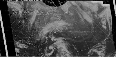
The national Weather Service provides that...
Marine Radiofacsimile is almost 90 years old! - The earliest broadcasts of weather maps via radiofacsimile appear to have been made in 1926 by American inventor Charles Francis Jenkins in a demonstration to the NAVY. Jenkins is often credited with the invention of the motion picture and later established the first U.S. TV station, W3XK in Wash D.C. and later, Wheaton, MD. RCA and the U.S. Weather Bureau conducted further tests and began cooperative efforts in 1930. While radiofacsimile has been used for everything from transmitting newspapers to wanted posters in the past, the broadcasting of marine weather charts is today the primary application.
The National Weather Service radiofax program prepares high seas weather maps for broadcast via four U.S. Coast Guard (Boston, New Orleans, Pt. Reyes, and Kodiak) and one DOD transmitter site (Honolulu). Limited satellite imagery, sea surface temperature maps and text forecasts are also available. These offices provide links to their products as well as other supplementary information.
All radiofax broadcasts of National Weather Service products employ a radiofax signal of 120 lines-per-minute (LPM) and an Index-of Cooperation (IOC) of 576. These values must be entered into the users equipment or software program in order for the radiofax image to be displayed properly.
See tables below for abbreviated versions of radiofax broadcast schedules. Assigned frequencies shown, for carrier frequency subtract 1.9 kHz. Typically dedicated radiofax receivers use assigned frequencies, while receivers or transceivers, connected to external recorders or PC's, are operated in the upper sideband (USB) mode using carrier frequencies.
| Boston (NMF) 4235(0230-1039z), 6340.5, 9110, 12750(1400-2239z) kHz Radiofax Broadcast | |||||||
| Start Broadcast | 0230Z | 0745Z | 1400Z | 1720Z | 1900Z | ||
| Broadcast Schedule | 0243Z | 1405Z | |||||
| International Ice Patrol (Seasonal, ~Feb- Sep) Call Letters NIK |
0438Z | 1039Z | 1600Z | 2239Z | |||
| New Orleans (NMG) 4317.9, 8503.9, 12789.9, 17146.4(1200-2045z) kHz Radiofax Broadcast | ||||
| Start Broadcast | 0000Z | 0600Z | 1200Z | 1800Z |
| Broadcast Schedule | 2025Z | |||
| Kodiak(NOJ) 2054, 4298, 8459, 12410.6 kHz Radiofax Broadcast | ||||
| Start Broadcast | 0340Z | 0950Z | 1540Z | 2150Z |
| Broadcast Schedule | 1727Z | |||
| Pt.Reyes(NMC) 4346(0140-1608z), 8682, 12786, 17151.2, 22527(1840-2356z) kHz Radiofax Broadcast | ||||||
| Start Broadcast | 0140Z | 0655Z | 1120Z | 1400Z | 1840Z | 2320Z |
| Broadcast Schedule | 1124Z | 2324Z | ||||
| Honolulu (KVM70) 9982.5(0519-1556z), 11090, 16135(1719-0356z) kHz Radiofax Broadcast | ||||
| Start Broadcast | 0519Z | 1719Z | ||
| Broadcast Schedule | 1300Z | 0100Z | ||
| (Note: DOD station, not USCG) | ||||
RADIOFAX IMAGES
* DEC 2016 ICEBERG CHART
East Coast US
GOES PHOTO
OCT 2016 Iceberg Chart
MEXICO GOES PHOTO
Central America Goes Image
These images were decoded with FLdigi in WEFAX mode. The NOAA charts are the easies to receive here in North America but there is a world wide source of these imahes,
Ocean Prefiction Center RADIOFAX USERS GUIDE
This publication provides detailed user information for these charts.
WORLDWIRD RADIOFAX LISTING


